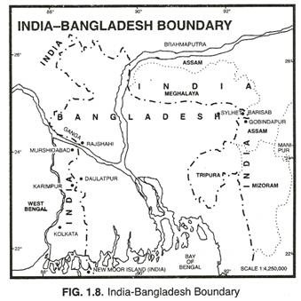
Here is your paragraph on India-Bangladesh Border:
Of all the neighbouring countries, India’s 4,096 km long border with Bangladesh is the longest and accounts for nearly 27 per cent of the total land border of India.
As many as five Indian states share the international boundary with Bangladesh. They are West Bengal, Assam, Meghalaya, Tripura and Mizoram.
The boundary line between India and Bangladesh criss-crosses the vast Ganga-Brahmaputra delta. This boundary runs through an entirely flat country, in which there is not even a small mound or hill which could be used for demarcating the boundary between the two countries. It is, therefore, a very unsatisfactory border because it fails to separate the people living on either side of the frontier.
ADVERTISEMENTS:
This boundary has been determined under the Radcliffe Award which divided the erstwhile province of Bengal into two parts. The eastern part went to the then East Pakistan which became independent country of Bangladesh in 1971, and western part remained with India as the state of West Bengal.
West Bengal has 2,272 km long border with Bangladesh which is the longest border shared by any Indian state with Bangladesh. Although Indo- Bangladesh border has remained more or less peaceful and there are no serious border problems between the two countries, yet there were four overlapping claims which were referred to the tribunal. The first was between Rajshahi of Bangladesh and Murshidabad of West Bengal (India).
ADVERTISEMENTS:
Here the channel of the Ganga fluctuates rather frequently as a result of which the boundary has shifted several times. The northern portion of the district was confirmed as the international boundary. The second dispute was between Karimpur (India) and Daulatpur (Bangladesh).
In this case, half way line in the Matabhanga River was treated as the international boundary. The third dispute was in Sylhet district of Bangladesh and Garo, Khasi, and Jaintia Hills district of Meghalaya in India. This is a densely forested area where demarcation is difficult. Here Radcliffe Award was confirmed and India’s claim was sustained. The fourth dispute existed between Barisari (Bangladesh) and Gobindpur (Assam).
Farakka barrage was another major issue between India and the then East Pakistan (now Bangladesh). Immediately after the Indus Water Treaty between India and Pakistan, a dispute arose over the use of the Ganga river water. India planned the construction of a barrage across the Ganga at Farakka.
This barrage aimed at rejuvenating the river system of West Bengal, flood control, efficient distribution of water between the northern and southern parts of West Bengal and for desalting the Kolkata harbour.
Pakistan feared that construction of Farakka barrage would seriously reduce water supply to East Pakistan. Negotiations failed to produce a settled agreement and the work on the construction of Farakka barrage started in mid 1960s.
ADVERTISEMENTS:
During the 1980s a refugee influx of Bangladeshis in Tripura and Assam created problems for India. By 1989 more than six lakh refugees from Bangladesh had entered India. The refugee influx continues even today, creating economic, social and political problems for India.
Currently, almost all the Indian states touching the Bangladesh border are infested by refugees from Bangladesh. India’s plan to erect barbed-wire fence along the Bangladesh border to check the illegal migration of refugees from Bangladesh has not been welcomed by that country.
In the beginning, the emergence of an independent and generally friendly country of Bangladesh in place of the initial East Pakistan was viewed positively by India. But the recent growth of anti-India elements backed by ISI of Pakistan is likely to create problems between the two countries.
