Here is your paragraph on the cold weather season or winter season in India !
The cold weather season commences in November and continues till March. Clear sky, pleasant weather, low temperature and humidity, high ranges of temperature cool and slow northern winds are the chief characteristics of this season.
(a) Temperature:
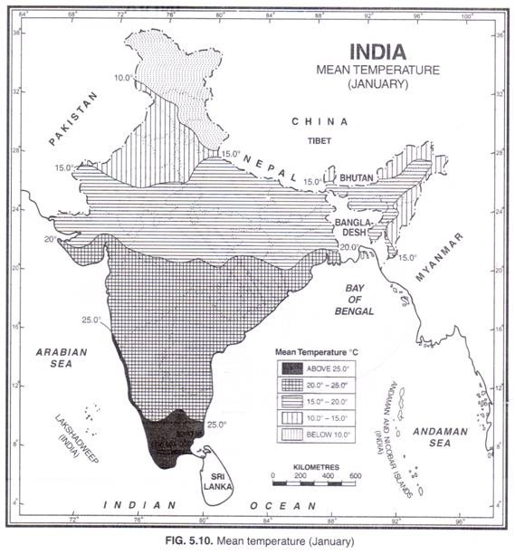
The northern two thirds of the country have mean temperatures below 21°C, with afternoon temperatures of 27°C.
ADVERTISEMENTS:
January is the coldest month when the temperature in the Ganga plain varies from 12.5° to 17.5°C. The mean minimum temperatures are about 5°C over northwest India and 10°C over the Gangetic plains.
However, on individual days the temperatures may fall much below the mean values. The night temperature often falls below freezing point in many hilly areas. Dras Valley in Kashmir is the coldest place in India. The minimum temperature recorded at Dras was -45°C on 28th December, 1908.
ADVERTISEMENTS:
The southern one-third has rather warm conditions and does not have distinctly defined winter weather. The isotherm of 20°C runs in east-west direction, roughly parallel to the Tropic of Cancer and divides India climatically in the northern and southern parts. To the south of this isotherm the temperatures are invariably above 20°C.
In the extreme south the temperature may be well above 25 °C (Fig. 5.10). January temperature at Thiruvananthapuram is 31°C. The diurnal range of temperature, especially in interior parts of the country, is very high. It may reach 15°C over western India.
(b) Pressure and Winds:
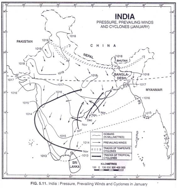
High air pressure prevails over large parts of north-west India due to low temperature conditions there. Normally the pressure varies from 1015 to 1020 mb. However pressure is comparatively lower in south India. The isobar of 1019 mb is seen in north-west India while the isobar of 1013 mb touches the southern tip of the country. (Fig. 5.11) The winds start blowing from high pressure area of north-west to low pressure area of south-east.
The wind velocity is low due to low pressure gradient. Depending upon the pressure and physiography, the winds blow from west and north-west in Punjab, Haryana, Uttar Pradesh and Bihar, from north-west in Bengal and from north-east in the Bay of Bengal.
Western Disturbances and Tropical Cyclones:
ADVERTISEMENTS:
Although sky is generally clear, the spell of fine weather is often broken due to inflow of depressions from the west. These low pressure depressions are called western disturbances. They originate in the Mediterranean Sea and enter India after crossing over Iraq, Iran, Afghanistan and Pakistan. On their way, their moisture content is augmented from the Caspian Sea and the Persian Gulf. They are often in an occluded form when they reach India.
They intensify over Rajasthan, Panjab, and Haryana. They move eastwards across the sub-Himalayan belt and reach right upto Arunachal Pradesh (Fig. 5.11), causing light rain in the Indo-Gangetic plains and snowfall in the Himalayan belt. After the passage of the disturbance, widespread fog and cold waves lowering the minimum temperature by 5° to 10°C below normal are experienced. Haze is common in morning and evening.
The frequency of the western disturbances varies from year to year but on an average 3 to 5 disturbance per month is experienced. According to W.G. Kendrew, the numbers of disturbances reaching India are 2 in November, 4 in December, 5 each in Jan. and Feb. and 4 in March. The jet stream plays an important role in bringing these disturbances to India.
This is the season of least tropical cyclone activity and the frequency decreases with the advancement of season. This is due to low sea surface temperature and the location of ITCZ farthest south in this season. The storms which are born in Bay of Bengal strike Tamil Nadu and some of them cross the southern peninsula over to Arabian Sea. Some storms originate in the Arabian Sea and move towards either north or west.
(c) Precipitation:
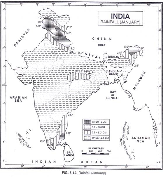
The retreating winter monsoons blow from land to sea and do not cause much rainfall. These winds pick up some moisture while crossing the Bay of Bengal and cause winter rainfall in Tamil Nadu, south Andhra Pradesh, south-east Karnataka and south-east Kerala. The highest seasonal rainfall of about 75 cm between October and December occurs along the south-eastern coast of Tamil Nadu and adjoining parts of south Andhra Pradesh. Thereafter, it gradually decreases except for a small area towards north-east Kerala.
The western disturbances also cause a little rainfall in north-west India. The amount of rainfall gradually decreases from the north and north-west to east. The average rainfall during three months from December to February is about 60 cm in the Himalayan region, 12 cm in Punjab, 5.3 cm at Delhi and 1.8 cm to 2.5 cm in U.P. and Bihar.
Although very small in amount, this rainfall is extremely useful for rabi crops, especially the wheat crop. The north-eastern part of India also gets rainfall during the winter months. Arunachal Pradesh and Assam may get as much as 50 cm of rainfall during these months. The distribution of winter rainfall in India is shown in Fig. 5.12.


